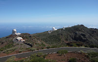
At the northwest of the Canaries archipelago , a few hundred miles from the coast of north-west Africa, lies the island of La Palma, also known as La Isla Bonita, because of its extraordinary natural beauty.


 La Palma is one of the smaller of the Canary islands, with a surface area of 706 square kilometres and a population of only 80,000. It is unusual in that it rises exceptionally steeply from the ocean, the entire central mountain range exceeding 2000 m in altitude. The highest point on the island is the Roque de los Muchachos (2426 m), the location of the astronomical observatory (one of most important observatory around the world).
The north of the island is dominated by the giant Caldera de Taburiente, from which the Cumbre Nueva and Cumbre Vieja ridges run due south to the sea.

 Like the rest of the Canary islands, the origin of La Palma is volcanic. There have been a number of eruptions in recent history, including those of Tacande, Volcan Martin , Volcan San Antonio, Charco and Las Manchas . The most recent volcanic eruption was that of Teneguia in 1971.
 The most important geological feature of La Palma is the Caldera de Taburiente, which dominates the northern part of the island. This is a large depression, 5 km across, with an area of 30 km, and 2 km deep. It originated 2 million years ago, with the formation of a shield volcano some 20 km in diameter. However, the Caldera was formed not by the original volcanic activity, but by subsequent erosion. The result is one of the largest and most impressive erosion craters in the world. .


No hay comentarios:
Publicar un comentario